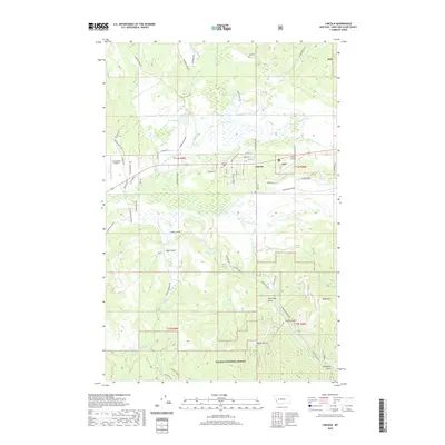
2020 Map of Lincoln
USGS Topo · Published 2020About this map
The mountain town of Lincoln sits along the winding upper reaches of the Blackfoot River, serving as a gateway to the high timber of the Helena National Forest. The landscape is defined by the transition from the river valley floor, where the Grosfield Ditch and Smith Lake indicate local water management, to the steep drainages of Bear Gulch and McCarthy Gulch. To the north, the Tuck Cem and two aviation facilities, Lincoln Airport and Cain Ranch Airport, mark the human footprint in this corner of Lewis and Clark County. The map details a network of creek-fed basins including Keep Cool Cr and Stonewall Creek, while the southern heights are dominated by Baldy Mtn. Many local routes such as Stemple Pass Rd and Sauerkraut Crk Rd provide access into the deeper gulches and mountain passes that have long supported the region's logging and ranching heritage.
Find a feature on this map
75 named features on this map. Tap any name to fly to it.
Don’t see what you’re looking for? This feature index may not catch every label — zoom into the map to look around manually.
Map Details
Editions of this 2020 Lincoln Map
This is the sole edition of this map. No revisions or reprints were ever made.
Other maps of this area

1889 · Helena
USGS Topo · 1:250,000

1893 · Helena
USGS Topo · 1:250,000

1899 · Helena
USGS Topo · 1:250,000

1903 · Coopers Lake
USGS Topo · 1:125,000

1903 · Helena
USGS Topo · 1:250,000

1947 · Butte
USGS Topo · 1:250,000

1955 · Choteau
USGS Topo · 1:250,000

1957 · Choteau
USGS Topo · 1:250,000

1958 · Butte
USGS Topo · 1:250,000

1958 · Choteau
USGS Topo · 1:250,000