2001 Map of Lincoln
USGS Topo · Published 2004About this map
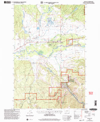
The town of Lincoln sits at the heart of this high-country landscape, positioned where the valley of the Blackfoot River opens up beneath the peaks of the Helena National Forest. By the early 2000s, the area reflects a mix of remote Montana ranching life and specialized infrastructure, featuring the Jacobson Ranch alongside the Lincoln Airport and its nearby Airway Beacon. The geography is defined by a dense network of water, with Keep Cool Creek and Poorman Creek draining the southern gulches. Local history is anchored by sites like the Lincoln Cemetery and the Rodeo Ground, while the Hooper State Park preserves riverfront space near the town center. The map also captures remnants of local industry and prospecting, noting several Gravel Pits and a Mine tucked into the steep drainages of McCarthy Gulch and Canyon Creek.
Find a feature on this map
36 named features on this map. Tap any name to fly to it.
Don’t see what you’re looking for? This feature index may not catch every label — zoom into the map to look around manually.
Map Details
Editions of this 2001 Lincoln Map
This is the sole edition of this map. No revisions or reprints were ever made.
Other maps of this area

1889 · Helena
USGS Topo · 1:250,000

1893 · Helena
USGS Topo · 1:250,000

1899 · Helena
USGS Topo · 1:250,000

1903 · Coopers Lake
USGS Topo · 1:125,000

1903 · Helena
USGS Topo · 1:250,000

1947 · Butte
USGS Topo · 1:250,000

1955 · Choteau
USGS Topo · 1:250,000

1957 · Choteau
USGS Topo · 1:250,000

1958 · Butte
USGS Topo · 1:250,000

1958 · Choteau
USGS Topo · 1:250,000