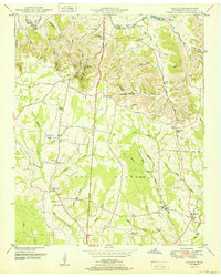
1951 Map of Lincoln
USGS Topo · Published 1951About this map
Elk River winds through the northern reaches of this Tennessee-Lincoln County border region, carving prominent bends such as Morgan Bend and Henry Bend. The landscape transitions from these river lowlands into the dissected uplands of Pea Ridge, a terrain defined by numerous hollows bearing local names like Locker Hollow and Blankenship Hollow. Small agricultural communities and rural crossroads anchor the 1951 settlement pattern, most notably the village of Lincoln and the community at Boone Falls.
Find a feature on this map
68 named features on this map. Tap any name to fly to it.
Don’t see what you’re looking for? This feature index may not catch every label — zoom into the map to look around manually.
Map Details
Editions of this 1951 Lincoln Map
This is the sole edition of this map. No revisions or reprints were ever made.
Other maps of this area

1888 · Scottsboro
USGS Topo · 1:125,000

1888 · Huntsville
USGS Topo · 1:125,000

1892 · Huntsville
USGS Topo · 1:125,000

1892 · Scottsboro
USGS Topo · 1:125,000

1936 · Flintville
USGS Topo · 1:24,000

1936 · Taft
USGS Topo · 1:24,000

1936 · Fisk
USGS Topo · 1:24,000

1936 · Boonshill
USGS Topo · 1:24,000

1936 · Lincoln
USGS Topo · 1:24,000

1936 · Toney
USGS Topo · 1:24,000