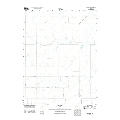
2012 Map of Lincoln NW
USGS Topo · Published 2012About this map
Rattlesnake Cr and Battle Cr define the drainage patterns across this rural section of Lincoln County, where the landscape is etched by a network of intermittent streams. The map reveals a strictly regulated agricultural grid system, typical of the Great Plains, where roads like Ash Grove Rd, Vine Dr, and E Teal Dr serve as the primary arteries for movement between sections. This 2012 survey captures the area's transition into the early 21st century, showing how modern county highways and local roads such as 140th Rd and 175th Rd continue to adhere to the historic sectional boundaries. Small tributaries like Little Timber Cr and Rock Cr cut across the geometric fields, illustrating the persistent influence of hydrology on land use in this open Kansas prairie.
Find a feature on this map
16 named features on this map. Tap any name to fly to it.
Don’t see what you’re looking for? This feature index may not catch every label — zoom into the map to look around manually.
Map Details
Editions of this 2012 Lincoln NW Map
This is the sole edition of this map. No revisions or reprints were ever made.
Other maps of this area

1894 · Beloit
USGS Topo · 1:125,000

1955 · Beloit
USGS Topo · 1:250,000

1959 · Beloit
USGS Topo · 1:250,000

1962 · Vesper
USGS Topo · 1:24,000

1962 · Lincoln
USGS Topo · 1:24,000
1963 · Shady Bend
USGS Topo · 1:24,000
1964 · Barnard
USGS Topo · 1:24,000
1964 · Beloit SE
USGS Topo · 1:24,000

1968 · Beloit SW
USGS Topo · 1:24,000

1968 · Lincoln NW
USGS Topo · 1:24,000