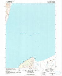
1993 Map of Lincoln Point
USGS Topo · Published 1994About this map
Lincoln Point anchors this southern portion of Utah Lake, illustrating the complex water management infrastructure of the late 20th century. The landscape is defined by the presence of an Aqueduct, a Canal, and a protective Levee system near Benjamin Slough. These man-made features contrast with the natural shoreline indentations like Little Cove and the small, isolated landform of Bird Island out in the water.
Find a feature on this map
18 named features on this map. Tap any name to fly to it.
Don’t see what you’re looking for? This feature index may not catch every label — zoom into the map to look around manually.
Map Details
Editions of this 1993 Lincoln Point Map
This is the sole edition of this map. No revisions or reprints were ever made.
Other maps of this area

1885 · Salt Lake
USGS Topo · 1:250,000

1948 · Spanish Fork
USGS Topo · 1:24,000

1948 · Orem
USGS Topo · 1:24,000

1948 · Orem
USGS Topo · 1:62,500

1948 · Provo
USGS Topo · 1:24,000

1949 · Provo
USGS Topo · 1:62,500

1950 · Orem
USGS Topo · 1:24,000

1950 · Provo
USGS Topo · 1:24,000

1950 · Spanish Fork
USGS Topo · 1:24,000

1950 · West Mountain
USGS Topo · 1:24,000