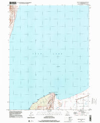
1997 Map of Lincoln Point
USGS Topo · Published 2001About this map
Utah Lake dominates this late-twentieth-century landscape, where the northern terminus of West Mountain juts into the water to form Lincoln Point. This prominent geographical feature is a focal point for local activity, evidenced by the Boat Ramp and the Pumping Sta Levee located at its tip. To the east, the terrain transitions into the low-lying Mud Flat and the marshy reaches of Benjamin Slough, reflecting the complex shoreline dynamics of the basin.
Find a feature on this map
15 named features on this map. Tap any name to fly to it.
Don’t see what you’re looking for? This feature index may not catch every label — zoom into the map to look around manually.
Map Details
Editions of this 1997 Lincoln Point Map
This is the sole edition of this map. No revisions or reprints were ever made.
Other maps of this area

1885 · Salt Lake
USGS Topo · 1:250,000

1948 · Spanish Fork
USGS Topo · 1:24,000

1948 · Orem
USGS Topo · 1:24,000

1948 · Orem
USGS Topo · 1:62,500

1948 · Provo
USGS Topo · 1:24,000

1949 · Provo
USGS Topo · 1:62,500

1950 · Orem
USGS Topo · 1:24,000

1950 · Provo
USGS Topo · 1:24,000

1950 · Spanish Fork
USGS Topo · 1:24,000

1950 · West Mountain
USGS Topo · 1:24,000