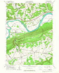
1965 Map of Linden
USGS Topo · Published 1967About this map
Bald Eagle Mountain dominates the central landscape of this Lycoming County survey, acting as a massive geological barrier between the Nippenose Valley to the south and the West Branch Susquehanna River valley to the north. The river corridor is a hub of mid-century infrastructure, featuring the New York Central rail line, the Jersey Shore Airport, and a Drive-in Theater near Level Corner. This period shows a transition in land use, where established agricultural hamlets like Antes Fort and Linden sit alongside newer developments such as the New Tribes Institute at Larryville. Further south, the map reveals the distinct cultural geography of the limestone valleys, marked by community centers like Oval, Collomsville, and Bastress, where the Immaculate Conception Sch and various churches anchor the rural population. Geologic features like Creek Sinks near Rauchtown suggest the complex karst drainage systems characteristic of the local terrain.
Find a feature on this map
60 named features on this map. Tap any name to fly to it.
Don’t see what you’re looking for? This feature index may not catch every label — zoom into the map to look around manually.
Map Details
Editions of this 1965 Linden Map
2 editions found
Other maps of this area

1921 · Williamsport
USGS Topo · 1:48,000

1921 · Trout Run
USGS Topo · 1:62,500

1921 · Lock Haven
USGS Topo · 1:62,500

1923 · Lock Haven
USGS Topo · 1:62,500

1923 · Trout Run
USGS Topo · 1:62,500

1923 · Williamsport
USGS Topo · 1:62,500

1935 · Waterville
USGS Topo · 1:24,000

1937 · Waterville
USGS Topo · 1:48,000

1943 · Waterville
USGS Topo · 1:62,500

1944 · Trout Run
USGS Topo · 1:62,500
Featured Places
- Bastress Township, PA
- Woodward Township, PA
- Mifflin Township, PA
- Limestone Township, PA
- Piatt Township, PA