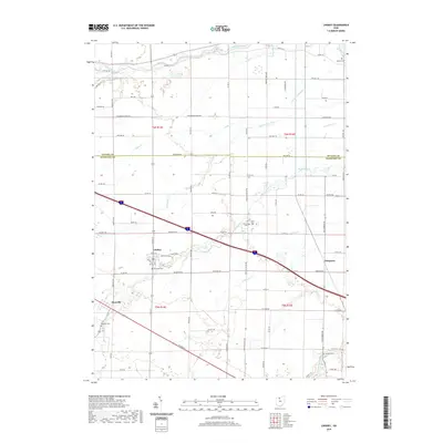
2019 Map of Lindsey
USGS Topo · Published 2019About this map
The Portage River and its complex network of tributaries, including Sugar Creek and Wolf Cr, dominate this section of the Northwest Ohio landscape along the boundary of Ottawa and Sandusky Counties. The village of Lindsey serves as a central hub, surrounded by smaller settlements like Hessville and Kingsway. The map reveals a dense agricultural and drainage history through features like Yauch Ditch and Cottonwood Swale, which illustrate how the land was managed to support farming in the former Great Black Swamp region. Genealogists will find a significant concentration of burial sites across the landscape, ranging from the Lindsey Cem in town to rural locations such as Roose Cem and Binkley Cem. The presence of Saint Pauls Cem and several family-named landmarks provides a clear view of the area's established community roots and nineteenth-century settlement patterns.
Find a feature on this map
90 named features on this map. Tap any name to fly to it.
Don’t see what you’re looking for? This feature index may not catch every label — zoom into the map to look around manually.
Map Details
Editions of this 2019 Lindsey Map
This is the sole edition of this map. No revisions or reprints were ever made.
Other maps of this area

1900 · Maumee Bay
USGS Topo · 1:62,500

1900 · Oak Harbor
USGS Topo · 1:62,500

1901 · Fremont
USGS Topo · 1:62,500

1901 · Elmore
USGS Topo · 1:62,500

1903 · Fremont
USGS Topo · 1:62,500

1903 · Elmore
USGS Topo · 1:62,500

1935 · Genoa
USGS Topo · 1:24,000
1938 · Genoa
USGS Topo · 1:31,680
1952 · Genoa
USGS Topo · 1:24,000

1952 · Oak Harbor
USGS Topo · 1:24,000