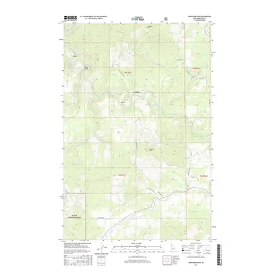
2017 Map of Lindstrom Peak
USGS Topo · Published 2017About this map
The Saint Maries River winds through the heart of the St Joe National Forest in this high-altitude portion of Benewah County. This 2017 terrain study highlights the rugged geography of the Idaho panhandle, anchored by prominent elevations such as Lindstrom Peak and Peterson Point. The landscape is defined by a dense network of mountain drainages, including Alder Creek, Johns Cr, and Santa Cr, which carve through the timbered slopes. Small settlements and former station points like Lotus, Rover, and Cardwell are positioned along the primary river valley and creek bottoms, indicating the historical pathways of transport and settlement in these tight corridors. A complex web of forest access routes, such as Peterson Lookout Rd and Ryan Loop, provide the necessary infrastructure for land management and recreation throughout the diverse elevations of the St. Joe region.
Find a feature on this map
32 named features on this map. Tap any name to fly to it.
Don’t see what you’re looking for? This feature index may not catch every label — zoom into the map to look around manually.
Map Details
Editions of this 2017 Lindstrom Peak Map
This is the sole edition of this map. No revisions or reprints were ever made.
Other maps of this area

1955 · Spokane
USGS Topo · 1:250,000

1957 · St. Maries
USGS Topo · 1:62,500

1957 · Emida
USGS Topo · 1:62,500

1957 · St. Joe
USGS Topo · 1:62,500

1958 · Spokane
USGS Topo · 1:250,000

1961 · Fernwood
USGS Topo · 1:62,500

1981 · St Maries
USGS Topo · 1:100,000
1981 · St Maries
USGS Topo · 1:24,000
1981 · Benewah Lake
USGS Topo · 1:24,000
1985 · St. Joe Baldy
USGS Topo · 1:24,000