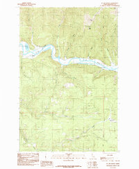
1985 Map of St. Joe Baldy
USGS Topo · Published 1985About this map
The St Joe River winds through the heart of this Idaho landscape, carving a deep valley between high peaks in Benewah County. Along its northern banks, Turtle Lake provides a natural landmark near the small settlement of Omega. The surrounding terrain is defined by dramatic elevation changes, rising from the river to notable summits like St Joe Baldy and Reeds Baldy.
Find a feature on this map
20 named features on this map. Tap any name to fly to it.
Don’t see what you’re looking for? This feature index may not catch every label — zoom into the map to look around manually.
Map Details
Editions of this 1985 St. Joe Baldy Map
This is the sole edition of this map. No revisions or reprints were ever made.
Other maps of this area

1950 · Rochat Peak
USGS Topo · 1:24,000

1950 · Twin Crags
USGS Topo · 1:24,000

1952 · Rochat Peak
USGS Topo · 1:24,000

1952 · Twin Crags
USGS Topo · 1:24,000

1955 · Spokane
USGS Topo · 1:250,000

1957 · St. Maries
USGS Topo · 1:62,500

1957 · Emida
USGS Topo · 1:62,500

1957 · St. Joe
USGS Topo · 1:62,500

1958 · Spokane
USGS Topo · 1:250,000

1961 · Fernwood
USGS Topo · 1:62,500