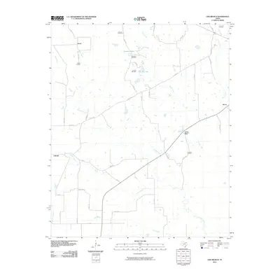
2010 Map of Line Branch
USGS Topo · Published 2010About this map
Liberty and its surrounding rural community in Red River County define this landscape, where family history is anchored by several long-established burial grounds. Researchers will find the Liberty Cemetery, Catonville Cemetery, Lone Star Cemetery, and Thompson Cemetery distributed across the prairie and woodland parcels. The area is defined by a dense network of seasonal waterways, including the winding Cuthand Creek, Gouchy Creek, and the eponymous Line Branch. Small-scale water management is evident through features like Deanborn Lake and Jan-Kay Lake, both created by earthen dams. These reservoirs, alongside the small settlements of Lone Star, McCoy, and Fulbright, illustrate the persistence of rural agricultural life in East Texas into the early 21st century. The map tracks the evolution of local transit from state-maintained routes like FM 411 to an intricate web of county roads that service the dispersed farmsteads.
Find a feature on this map
46 named features on this map. Tap any name to fly to it.
Don’t see what you’re looking for? This feature index may not catch every label — zoom into the map to look around manually.
Map Details
Editions of this 2010 Line Branch Map
This is the sole edition of this map. No revisions or reprints were ever made.
Other maps of this area

1953 · Texarkana
USGS Topo · 1:250,000

1956 · Texarkana
USGS Topo · 1:250,000

1963 · Cunningham
USGS Topo · 1:24,000

1964 · Detroit
USGS Topo · 1:24,000

1964 · Deport
USGS Topo · 1:24,000

1964 · Bagwell
USGS Topo · 1:24,000

1964 · Cuthand
USGS Topo · 1:24,000

1964 · Bogata
USGS Topo · 1:24,000
1964 · Dimple
USGS Topo · 1:24,000
1964 · Line Branch
USGS Topo · 1:24,000