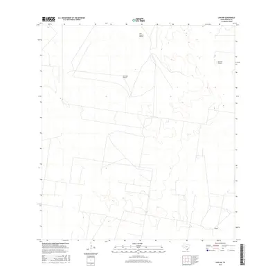
2016 Map of Linn NW
USGS Topo · Published 2016About this map
Large-scale ranching and land divisions define this portion of Hidalgo County, characterized by expansive pastures and the small settlement of Linn. The landscape is organized into named tracts such as San Juan Pasture, Tres Lagunas Pasture, and Santa Fe Pasture, reflecting the heritage of South Texas land management. A network of local roads and unimproved trails crisscrosses the terrain, providing access to these broad holdings. This survey captures the subtle topography of the region, where the historical footprint of these named pastures remains the primary identifier for the landscape north of the more densely populated Rio Grande Valley.
Find a feature on this map
4 named features on this map. Tap any name to fly to it.
Don’t see what you’re looking for? This feature index may not catch every label — zoom into the map to look around manually.
Map Details
Editions of this 2016 Linn NW Map
This is the sole edition of this map. No revisions or reprints were ever made.
Other maps of this area

1939 · Linn
USGS Topo · 1:62,500

1939 · La Reforma
USGS Topo · 1:62,500

1939 · Encantada
USGS Topo · 1:62,500

1949 · Mc Allen
USGS Topo · 1:250,000

1954 · McAllen
USGS Topo · 1:250,000

1957 · Mc Allen
USGS Topo · 1:250,000

1962 · McAllen
USGS Topo · 1:250,000
1963 · Callo Padrones
USGS Topo · 1:24,000

1963 · Linn NW
USGS Topo · 1:24,000
1963 · Linn Siding
USGS Topo · 1:24,000