
1934 Map of Linn
USGS Topo · Published 1934About this map
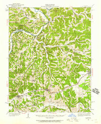
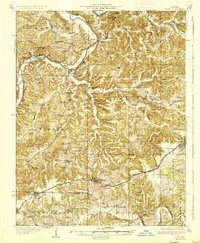
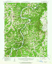
The confluence of the Gasconade River and its various tributaries, including the winding Maries River, dominates this mid-1930s survey of Osage County. The landscape is defined by its rural density, featuring a high concentration of local schools such as Lone Star Sch, Victor Sch, and Buck Elk Sch that served the dispersed farming communities between the hills. The Chicago Rock Island and Pacific RR cuts through the southern portion of the quadrangle, facilitating the movement of goods through Freeburg and Summerfield.
Find a feature on this map
50 named features on this map. Tap any name to fly to it.
Don’t see what you’re looking for? This feature index may not catch every label — zoom into the map to look around manually.
Map Details
Editions of this 1934 Linn Map
This is the sole edition of this map. No revisions or reprints were ever made.
Other maps of this area

1886 · Jefferson City
USGS Topo · 1:125,000

1888 · Tuscumbia
USGS Topo · 1:125,000

1890 · Fulton
USGS Topo · 1:125,000

1894 · Tuscumbia
USGS Topo · 1:125,000

1894 · Jefferson City
USGS Topo · 1:125,000
1934 · Bland
USGS Topo · 1:62,500

1934 · Redbird
USGS Topo · 1:62,500

1935 · Morrison
USGS Topo · 1:48,000
1937 · Bland
USGS Topo · 1:62,500
1937 · Vienna
USGS Topo · 1:62,500