
1942 Map of Linn
USGS Topo · Published 1959About this map
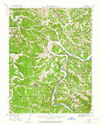
Linn and the surrounding Osage County highlands are shown here just as the World War II era began, characterized by a dense network of rural schools and winding river valleys. The Gasconade River and Maries River carve through the terrain, creating natural crossings like Daggetts Ford and Hoops Ford. The Rock Island railroad line cuts through the southern portion of the map, serving small settlements such as Gascondy and Freeburg. Local history and genealogy are anchored by numerous named schoolhouses, including Potts Sch, McDaniel Sch, and Vinton Sch, alongside family landmarks like the Van Buren Cem. The landscape reveals a deeply integrated rural society where isolated valleys like Knight Hollow and Blue Hollow were connected by a intricate web of unimproved roads and creek crossings.
Find a feature on this map
63 named features on this map. Tap any name to fly to it.
Don’t see what you’re looking for? This feature index may not catch every label — zoom into the map to look around manually.
Map Details
Editions of this 1942 Linn Map
2 editions found
Other maps of this area

1886 · Jefferson City
USGS Topo · 1:125,000

1888 · Tuscumbia
USGS Topo · 1:125,000

1890 · Fulton
USGS Topo · 1:125,000

1894 · Tuscumbia
USGS Topo · 1:125,000

1894 · Jefferson City
USGS Topo · 1:125,000

1934 · Linn
USGS Topo · 1:48,000

1934 · Bland
USGS Topo · 1:62,500

1934 · Redbird
USGS Topo · 1:62,500

1935 · Morrison
USGS Topo · 1:48,000

1937 · Bland
USGS Topo · 1:62,500