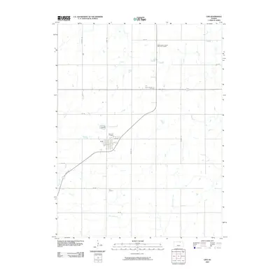
2009 Map of Linn
USGS Topo · Published 2009About this map
The town of Linn serves as the central hub of this northern Kansas landscape, where the grid-like precision of local roads like National Rd and Rainbow Rd meets the winding paths of several drainage systems. Genealogists will find significant local history preserved at the City Cemetery, Saint Paul Cemetery, and Zion Cemetery, alongside the uniquely named District Number 17 Cemetery located north of State Hwy 9. The terrain is defined by the headwaters and seasonal flows of Coon Creek, Peats Creek, and West Fancy Creek, which create subtle variations in the agricultural plains. Aviation history in the county is anchored by the Washington County Memorial Airport, situated near the intersection of the primary state highway and local township roads.
Find a feature on this map
26 named features on this map. Tap any name to fly to it.
Don’t see what you’re looking for? This feature index may not catch every label — zoom into the map to look around manually.
Map Details
Editions of this 2009 Linn Map
This is the sole edition of this map. No revisions or reprints were ever made.
Other maps of this area

1889 · Marysville
USGS Topo · 1:125,000

1893 · Washington
USGS Topo · 1:125,000

1894 · Marysville
USGS Topo · 1:125,000

1955 · Manhattan
USGS Topo · 1:250,000

1956 · Manhattan
USGS Topo · 1:250,000

1957 · Manhattan
USGS Topo · 1:250,000

1966 · Morrowville
USGS Topo · 1:24,000

1966 · Washington
USGS Topo · 1:24,000

1966 · Hanover SW
USGS Topo · 1:24,000
1968 · Linn SW
USGS Topo · 1:24,000