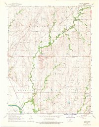
1968 Map of Linn SW
USGS Topo · Published 1969About this map
Republican River winds through the southwestern corner of this agricultural landscape at the border of Washington and Clay Counties. The map reveals a deeply etched drainage pattern defined by Peats Creek and Spring Creek, which cut through the townships of Sheridan, Sherman, Garfield, and Mulberry. This mid-century survey captures a rural network reliant on rail and local centers, anchored by Garfield Center in the southeast. Cultural landmarks include the Faith United Ch, and several burial grounds such as Peats Creek Cem, Sherman Cem, and Norwegian Cem, suggesting the diverse heritage of early settlers in the region. Transportation is dominated by the Missouri Pacific and Chicago Rock Island and Pacific railroads, which parallel the river and creek valleys, while a series of modern pipelines cross the northern sections of the terrain.
Find a feature on this map
19 named features on this map. Tap any name to fly to it.
Don’t see what you’re looking for? This feature index may not catch every label — zoom into the map to look around manually.
Map Details
Editions of this 1968 Linn SW Map
This is the sole edition of this map. No revisions or reprints were ever made.
Other maps of this area

1891 · Clay Center
USGS Topo · 1:125,000

1893 · Washington
USGS Topo · 1:125,000

1955 · Manhattan
USGS Topo · 1:250,000

1956 · Manhattan
USGS Topo · 1:250,000

1957 · Manhattan
USGS Topo · 1:250,000

1964 · Clay Center NW
USGS Topo · 1:24,000
1964 · Clay Center NE
USGS Topo · 1:24,000

1964 · Miltonvale NE
USGS Topo · 1:24,000

1965 · Clifton
USGS Topo · 1:24,000

1965 · Brantford
USGS Topo · 1:24,000