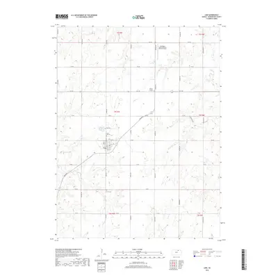
2018 Map of Linn
USGS Topo · Published 2018About this map
Linn serves as the central hub of this agricultural landscape in Washington County, where the town's grid is flanked by significant local history sites. For genealogists and researchers, the map provides precise locations for Saint Paul Cem and Zion Cem just north of the town center, while the larger Linn City Cem lies to the south along Osage Road. The terrain is defined by the drainage patterns of Coon Cr and Ash Cr, which cut through the sections of the Public Land Survey System. To the northeast, the Washington County Veteran's Memorial Airport represents a modern landmark amidst the traditional farmstead layout of the Kansas plains. This survey captures the enduring rural structure of the region, anchored by the town and its outlying district markers like District Number 17 Cem.
Find a feature on this map
15 named features on this map. Tap any name to fly to it.
Don’t see what you’re looking for? This feature index may not catch every label — zoom into the map to look around manually.
Map Details
Editions of this 2018 Linn Map
This is the sole edition of this map. No revisions or reprints were ever made.
Other maps of this area

1889 · Marysville
USGS Topo · 1:125,000

1893 · Washington
USGS Topo · 1:125,000

1894 · Marysville
USGS Topo · 1:125,000

1955 · Manhattan
USGS Topo · 1:250,000

1956 · Manhattan
USGS Topo · 1:250,000

1957 · Manhattan
USGS Topo · 1:250,000

1966 · Morrowville
USGS Topo · 1:24,000

1966 · Washington
USGS Topo · 1:24,000

1966 · Hanover SW
USGS Topo · 1:24,000
1968 · Linn SW
USGS Topo · 1:24,000