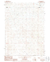
1986 Map of Linscott
USGS Topo · Published 1987About this map
Linscott serves as the primary focal point in this portion of the Nebraska Sandhills, situated along the northern boundary where Blaine Co and Custer Co meet. The landscape is defined by the drainage of Rifle Creek and the broad expanse of Sand Valley, which stretches across the southern reaches of the quadrangle. The presence of the McGinn Landing Strip near the creek reflects the necessity of aerial transport and surveying in this sparsely populated cattle country during the mid-1980s. This survey, based on 1983 aerial photography, captures the rural section lines and township boundaries of T 21 N and T 20 N as they were maintained before modern GPS-led precision altered ranching infrastructure.
Find a feature on this map
8 named features on this map. Tap any name to fly to it.
Don’t see what you’re looking for? This feature index may not catch every label — zoom into the map to look around manually.
Map Details
Editions of this 1986 Linscott Map
This is the sole edition of this map. No revisions or reprints were ever made.
Other maps of this area

1948 · Linscott
USGS Topo · 1:62,500

1950 · Linscott
USGS Topo · 1:62,500

1951 · Dunning
USGS Topo · 1:62,500

1951 · Anselmo SW
USGS Topo · 1:24,000

1951 · Anselmo NW
USGS Topo · 1:24,000

1952 · Brewster SW
USGS Topo · 1:24,000

1954 · North Platte
USGS Topo · 1:250,000

1955 · Broken Bow
USGS Topo · 1:250,000

1956 · Broken Bow
USGS Topo · 1:250,000

1956 · North Platte
USGS Topo · 1:250,000