
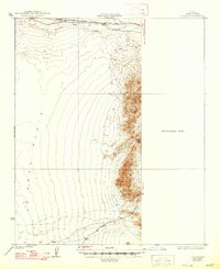
1930 Map of Linskey
USGS Topo · Published 1930About this map
Atchison Topeka and Santa Fe railroad tracks skirt the northern edge of this arid landscape, passing through the remote siding of Linskey. Published under the administration of Governor Geo. W. P. Hunt, the map documents a territory defined by the broad La Posa Plain and the eastern rise of the Plomosa Mountains. To the south, a desert road labeled Sunkist cuts across the alluvial fans, while isolated water sources like Tenmile Well and the ephemeral Bouse Wash represent the only relief in a terrain dominated by sharp peaks like Four Peaks. The eastern portion of the sheet remains designated as a Preliminary Edition Unsurveyed Area, reflecting the ongoing efforts of the Geological Survey to map these more difficult reaches of the Colorado Desert during the late 1920s.
Find a feature on this map
9 named features on this map. Tap any name to fly to it.
Don’t see what you’re looking for? This feature index may not catch every label — zoom into the map to look around manually.
Map Details
Editions of this 1930 Linskey Map
2 editions found
Other maps of this area

1911 · Parker
USGS Topo · 1:125,000

1923 · Signal
USGS Topo · 1:250,000

1931 · Moon Mtn
USGS Topo · 1:62,500

1932 · Moon Mtn
USGS Topo · 1:62,500

1933 · Cunningham Mtn
USGS Topo · 1:48,000

1940 · Dome Rock Mts
USGS Topo · 1:62,500

1942 · Signal
USGS Topo · 1:250,000

1942 · Blythe
USGS Topo · 1:250,000

1942 · Vicksburg
USGS Topo · 1:250,000

1942 · MOON MTN
USGS Topo · 1:62,500