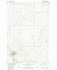
1980 Map of Linton
USGS Topo · Published 1980About this map
Linton serves as the primary hub of this North Dakota landscape, situated at the confluence of agricultural and early industrial interests. The town is flanked by several cultural landmarks, including the Linton Country Club and a Drive-in Theater along the southern approaches. For researchers of local history and industry, the presence of a Volcanic Ash Pit east of the town center indicates the unique geological composition of the region, while numerous Gravel Pits follow the path of Spring Creek and Beaver Creek. The transportation network is defined by the Chicago Milwaukee St Paul and Pacific railroad line, which skirts the western edge of the settlement. Further east, the Springwater Lake National Wildlife Refuge provides a contrast to the surrounding section-line farming developments, preserving the natural riparian environment of Clear Creek.
Find a feature on this map
19 named features on this map. Tap any name to fly to it.
Don’t see what you’re looking for? This feature index may not catch every label — zoom into the map to look around manually.
Map Details
Editions of this 1980 Linton Map
This is the sole edition of this map. No revisions or reprints were ever made.
Other maps of this area

1954 · Bismarck
USGS Topo · 1:250,000

1958 · Bismarck
USGS Topo · 1:250,000

1971 · Hazelton
USGS Topo · 1:24,000

1971 · Grassna NE
USGS Topo · 1:24,000

1971 · Strasburg
USGS Topo · 1:24,000

1971 · Temvik
USGS Topo · 1:24,000

1975 · Appert Lake
USGS Topo · 1:24,000

1975 · Linton NE
USGS Topo · 1:24,000

1979 · Senger Lake North
USGS Topo · 1:24,000
1980 · Rohrich Dam
USGS Topo · 1:24,000