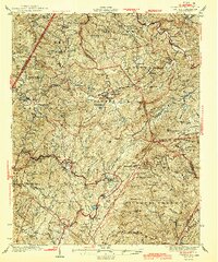
1944 Map of Linville
USGS Topo · Published 1944About this map
Beech Mountain and the surrounding high country are captured here during a period of transition, just as the Blue Ridge Parkway was being established through the area. The landscape is dotted with several rural institutions of the mid-1930s, including the Grandfather Orphanage near Banner Elk and the Hawshore Mtn Fire Tower overlooking the western ridges. Settlement patterns follow the winding paths of the Elk River and Linville River, with small community hubs such as Valle Crucis, Montezuma, and Pineola serving as local anchors. This survey documents the pre-war network of mountain roads like the Yonahlosee Road and numerous country schools such as Sugar Mtn Sch and Beech Creek Sch, providing a detailed look at the social geography of the Blue Ridge before later modernizations altered these isolated valleys.
Find a feature on this map
56 named features on this map. Tap any name to fly to it.
Don’t see what you’re looking for? This feature index may not catch every label — zoom into the map to look around manually.
Map Details
Editions of this 1944 Linville Map
2 editions found

Other maps of this area

1891 · Roan Mountain
USGS Topo · 1:125,000

1893 · Cranberry
USGS Topo · 1:125,000

1894 · Roan Mountain
USGS Topo · 1:125,000

1895 · Cranberry
USGS Topo · 1:125,000

1899 · Cranberry
USGS Topo · 1:125,000

1900 · Mount Mitchell
USGS Topo · 1:125,000

1902 · Cranberry
USGS Topo · 1:125,000

1902 · Mount Mitchell
USGS Topo · 1:125,000

1904 · Roan Mountain
USGS Topo · 1:125,000

1905 · Morganton
USGS Topo · 1:125,000