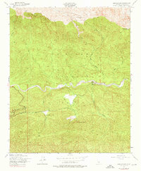
1943 Map of Lion Canyon
USGS Topo · Published 1976About this map
Pine Mountain dominates the northern reaches of this landscape, which was documented during the early 1940s within the Los Padres National Forest. The map centers on the winding course of Sespe Creek, which serves as a vital drainage for the surrounding canyons. Notable land use is marked by several remote outposts and settlements, including the Pine Mountain Lodge at high elevation and the Circle B Ranch situated in the valley below.
Find a feature on this map
21 named features on this map. Tap any name to fly to it.
Don’t see what you’re looking for? This feature index may not catch every label — zoom into the map to look around manually.
Map Details
Editions of this 1943 Lion Canyon Map
4 editions found
Other maps of this area

1903 · Santa Paula
USGS Topo · 1:62,500

1903 · Mt. Pinos
USGS Topo · 1:125,000

1904 · Ventura
USGS Topo · 1:62,500

1941 · Ventura
USGS Topo · 1:62,500

1942 · Santa Paula
USGS Topo · 1:62,500

1942 · Wheeler Springs
USGS Topo · 1:24,000

1943 · Topatopa Mountains
USGS Topo · 1:24,000

1943 · San Guillermo
USGS Topo · 1:24,000

1943 · Lockwood Valley
USGS Topo · 1:24,000

1943 · Lion Canyon
USGS Topo · 1:24,000