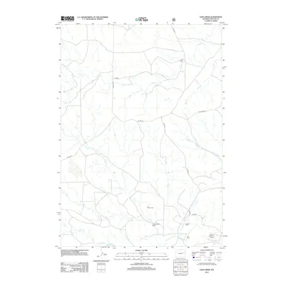
2012 Map of Lion Creek
USGS Topo · Published 2012About this map
Frog Creek Oil Field and various family-named cattle ranches define this portion of Weston County, where the high plains landscape is carved by a network of seasonal drainages. Established ranching operations like the Lynch Ranch, Bernard Ranch, and W 4 Ranch are connected by a sparse grid of gravel and dirt roads including Lynch Rd and Rochelle Rd. The northernmost reaches of the Cheyenne River cross the southern edge of the sheet near Sherwin Field Nr 1 Airport, while the tiny settlement of Rochelle sits at a remote crossroads to the north. Topographically, the land is characterized by named watercourses such as Lion Cr and Horse Cr, alongside the broad depression of Underwood Draw, illustrating the vital importance of water access and mineral extraction to the local Wyoming economy.
Find a feature on this map
18 named features on this map. Tap any name to fly to it.
Don’t see what you’re looking for? This feature index may not catch every label — zoom into the map to look around manually.
Map Details
Editions of this 2012 Lion Creek Map
This is the sole edition of this map. No revisions or reprints were ever made.
Other maps of this area

1955 · Newcastle
USGS Topo · 1:250,000

1958 · Newcastle
USGS Topo · 1:250,000

1971 · Fiddleback Ranch
USGS Topo · 1:24,000

1971 · Piney Canyon NE
USGS Topo · 1:24,000

1971 · Piney Canyon SE
USGS Topo · 1:24,000

1974 · Reno Junction
USGS Topo · 1:100,000

1979 · Newcastle
USGS Topo · 1:100,000

1979 · Bill
USGS Topo · 1:100,000
1981 · Wagonhound Creek
USGS Topo · 1:24,000

1981 · Wagonhound Creek NE
USGS Topo · 1:24,000