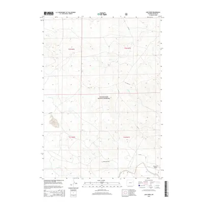
2015 Map of Lion Creek
USGS Topo · Published 2015About this map
Thunder Basin National Grassland dominates this portion of the high plains in Weston County, showing a landscape defined by expansive drainage networks and remote ranch access roads. The Cheyenne River flows through the southeastern corner, serving as the primary drainage for the many creeks that carve through the local topography, including Lion Cr, Horse Cr, and Cottonwood Cr. Human activity in this rural expanse is centered on infrastructure like Lynch Rd and Rochelle Rd, which provide access to scattered homesteads and livestock operations. A notable landmark for regional aviation is the Sherwin Field Number 1 Airport situated near the river, illustrating the importance of small airstrips in navigating this isolated Wyoming terrain. The map's contour lines reveal the subtle but complex system of draws and breaks, such as Underwood Draw, which shape the grazing lands of the western frontier.
Find a feature on this map
17 named features on this map. Tap any name to fly to it.
Don’t see what you’re looking for? This feature index may not catch every label — zoom into the map to look around manually.
Map Details
Editions of this 2015 Lion Creek Map
This is the sole edition of this map. No revisions or reprints were ever made.
Other maps of this area

1955 · Newcastle
USGS Topo · 1:250,000

1958 · Newcastle
USGS Topo · 1:250,000

1971 · Fiddleback Ranch
USGS Topo · 1:24,000

1971 · Piney Canyon NE
USGS Topo · 1:24,000

1971 · Piney Canyon SE
USGS Topo · 1:24,000

1974 · Reno Junction
USGS Topo · 1:100,000

1979 · Newcastle
USGS Topo · 1:100,000

1979 · Bill
USGS Topo · 1:100,000
1981 · Wagonhound Creek
USGS Topo · 1:24,000

1981 · Wagonhound Creek NE
USGS Topo · 1:24,000