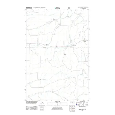
2011 Map of Lippert Gulch
USGS Topo · Published 2011About this map
Kieckbusch Homestead and several family-named ranches anchor the drainage basins of Broadwater County on this 2011 survey. The landscape is defined by the convergence of steep drainages, most notably Lippert Gulch and Flume Hollow, which feed into the larger watercourses of Cottonwood Creek and Deep Creek. The map documents a sparsely populated ranching territory where local infrastructure is tied to these natural corridors, with Deep Creek Pavillion serving as a localized point of interest along the creek bed.
Find a feature on this map
35 named features on this map. Tap any name to fly to it.
Don’t see what you’re looking for? This feature index may not catch every label — zoom into the map to look around manually.
Map Details
Editions of this 2011 Lippert Gulch Map
This is the sole edition of this map. No revisions or reprints were ever made.
Other maps of this area

1886 · Fort Logan
USGS Topo · 1:250,000

1948 · White Sulphur Springs
USGS Topo · 1:250,000

1949 · Maudlow
USGS Topo · 1:62,500

1949 · Toston
USGS Topo · 1:62,500

1950 · Duck Creek Pass
USGS Topo · 1:62,500

1958 · White Sulphur Springs
USGS Topo · 1:250,000

1961 · White Sulphur Springs
USGS Topo · 1:250,000

1965 · White Sulphur Springs
USGS Topo · 1:250,000
1971 · Mount Edith
USGS Topo · 1:24,000
1971 · Sulphur Bar Creek
USGS Topo · 1:24,000