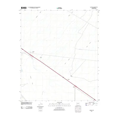
2010 Map of Lisbon
USGS Topo · Published 2010About this map
Lordsburg Valley dominates this high-desert landscape in southwest New Mexico, where the infrastructure of water and transport dictates the pattern of human activity. The settlement of Lisbon and the nearby siding at Muir represent small nodes along the primary rail and road corridor, while the historical Butterfield Trl cuts across the northern desert, marking an older era of westward travel. The reliance on groundwater in this arid climate is evident through a series of named water points including the Mesquite Windmill, North Lisbon Windmill, and South Lisbon Windmill, as well as the Lordsburg Pumping State facility. Seasonal drainage patterns are recorded in the topography through features like Burro Cienaga and various washes emerging from Jones Canyon and Engineer Canyon, illustrating how the desert floor is shaped by occasional runoff from the surrounding uplands.
Find a feature on this map
13 named features on this map. Tap any name to fly to it.
Don’t see what you’re looking for? This feature index may not catch every label — zoom into the map to look around manually.
Map Details
Editions of this 2010 Lisbon Map
This is the sole edition of this map. No revisions or reprints were ever made.
Other maps of this area

1954 · Silver City
USGS Topo · 1:250,000

1958 · Silver City
USGS Topo · 1:250,000

1962 · Silver City
USGS Topo · 1:250,000

1962 · Ninetysix Ranch
USGS Topo · 1:24,000

1962 · Lisbon
USGS Topo · 1:24,000

1963 · Lordsburg
USGS Topo · 1:24,000

1963 · Gold Hill
USGS Topo · 1:24,000

1963 · Culberson Ranch
USGS Topo · 1:24,000
1963 · C Bar Ranch
USGS Topo · 1:24,000

1964 · Muir Ranch
USGS Topo · 1:24,000