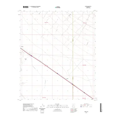
2023 Map of Lisbon
USGS Topo · Published 2023About this map
Lordsburg Valley dominates the arid southwestern New Mexico landscape of this 2023 survey, revealing the sparse but essential infrastructure of the high desert. The map tracks the passage of major transportation corridors through a region characterized by wide basins and seasonal drainages. Scattered settlements like Lisbon and Ulmoris appear as small hubs along the primary road network, which includes Co RD b001 and Co RD b002. The natural geography is defined by the ephemeral Burro Cienaga and various carved features such as Walker Canyon and Engineer Canyon to the north. This modern mapping illustrates how political and land survey lines, including the Hidalgo and Grant County border, are superimposed over a landscape where water and transit remain the primary drivers of human presence.
Find a feature on this map
17 named features on this map. Tap any name to fly to it.
Don’t see what you’re looking for? This feature index may not catch every label — zoom into the map to look around manually.
Map Details
Editions of this 2023 Lisbon Map
This is the sole edition of this map. No revisions or reprints were ever made.
Other maps of this area

1954 · Silver City
USGS Topo · 1:250,000

1958 · Silver City
USGS Topo · 1:250,000

1962 · Silver City
USGS Topo · 1:250,000

1962 · Ninetysix Ranch
USGS Topo · 1:24,000

1962 · Lisbon
USGS Topo · 1:24,000

1963 · Lordsburg
USGS Topo · 1:24,000

1963 · Gold Hill
USGS Topo · 1:24,000

1963 · Culberson Ranch
USGS Topo · 1:24,000
1963 · C Bar Ranch
USGS Topo · 1:24,000

1964 · Muir Ranch
USGS Topo · 1:24,000