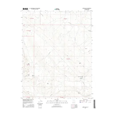
2017 Map of Lisbon Valley
USGS Topo · Published 2017About this map
Lisbon Valley forms the central character of this Southeast Utah landscape, which is defined by a series of parallel northwest-to-southeast trending valleys and canyons. The Big Indian Valley and the distinctive landmark of Big Indian Rock dominate the western portion of the sheet, while the elevation rises toward Mid Mesa and Three Step Hill in the east.
Find a feature on this map
29 named features on this map. Tap any name to fly to it.
Don’t see what you’re looking for? This feature index may not catch every label — zoom into the map to look around manually.
Map Details
Editions of this 2017 Lisbon Valley Map
This is the sole edition of this map. No revisions or reprints were ever made.
Other maps of this area

1885 · La Sal
USGS Topo · 1:250,000

1954 · Mt Peale 1 SE
USGS Topo · 1:24,000

1954 · Mt Peale 4 NE
USGS Topo · 1:24,000

1954 · Mt Peale 4 NW
USGS Topo · 1:24,000

1954 · Mt Peale 3 NE
USGS Topo · 1:24,000

1954 · Mt Peale 3 SE
USGS Topo · 1:24,000

1954 · Mt Peale 1 SW
USGS Topo · 1:24,000
1954 · Mt Peale 4 SE
USGS Topo · 1:24,000

1954 · Mt Peale 2 SE
USGS Topo · 1:24,000

1954 · Mt Peale 4 SW
USGS Topo · 1:24,000