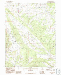
1987 Map of Lisbon Valley
USGS Topo · Published 1987About this map
Lisbon Valley forms a dramatic northwest-southeast corridor through the high plateau country of San Juan County, revealing a landscape defined by industrial extraction and stark geological landmarks. The 1987 survey identifies numerous mining operations and prospects, including the Louise Mine and Cub Mine, as well as a specific Mine Shaft located near the southern boundary. This concentration of features underscores the area's significance for mineral exploration during the late 20th century. The terrain is bounded by prominent elevations such as Middle Mesa to the east and the rising slopes of Three Step Hill to the south. Water sources are scarce but critical, marked by the presence of Lisbon Spring and the drainage network of East Coyote Wash, Big Indian Wash, and the ephemeral Little Dry Wash. Big Indian Rock stands as a notable landmark amidst the complex topography of canyons and washes like Spiller Canyon and Lisbon Canyon.
Find a feature on this map
15 named features on this map. Tap any name to fly to it.
Don’t see what you’re looking for? This feature index may not catch every label — zoom into the map to look around manually.
Map Details
Editions of this 1987 Lisbon Valley Map
This is the sole edition of this map. No revisions or reprints were ever made.
Other maps of this area

1885 · La Sal
USGS Topo · 1:250,000

1954 · Mt Peale 1 SE
USGS Topo · 1:24,000

1954 · Mt Peale 4 NE
USGS Topo · 1:24,000

1954 · Mt Peale 4 NW
USGS Topo · 1:24,000

1954 · Mt Peale 3 NE
USGS Topo · 1:24,000

1954 · Mt Peale 3 SE
USGS Topo · 1:24,000

1954 · Mt Peale 1 SW
USGS Topo · 1:24,000
1954 · Mt Peale 4 SE
USGS Topo · 1:24,000

1954 · Mt Peale 2 SE
USGS Topo · 1:24,000

1954 · Mt Peale 4 SW
USGS Topo · 1:24,000