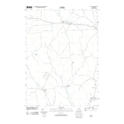
2010 Map of Lisle
USGS Topo · Published 2010About this map
Dudley Creek and the Tioughnioga River define the northern valley landscape of this region, where the historic settlements of Lisle and Center Lisle are connected by a network of upland roads. The terrain is marked by numerous family-named landmarks and ridge-top roads such as Whiting Hill Rd and Howland Hill Rd, reflecting a landscape deeply tied to its agrarian roots. In the southern portion of the map, Nanticoke Creek and its tributaries, including Ketchumville Branch, carve through the hills near the small hamlets of Nanticoke and Ketchumville. For family historians, the inclusion of the Center Lisle Cemetery, Mount Hunger Cemetery, and Glen Aubrey Cemetery provides essential geographic context for the area's ancestral residents. The map also captures modern land use, from the Grandview Farms Golf Course to local operations like the Greennuns Tree Farm.
Find a feature on this map
61 named features on this map. Tap any name to fly to it.
Don’t see what you’re looking for? This feature index may not catch every label — zoom into the map to look around manually.
Map Details
Editions of this 2010 Lisle Map
This is the sole edition of this map. No revisions or reprints were ever made.
Other maps of this area

1901 · Apalachin
USGS Topo · 1:62,500

1903 · Harford
USGS Topo · 1:62,500

1904 · Binghamton
USGS Topo · 1:62,500

1904 · Greene
USGS Topo · 1:62,500

1904 · Apalachin
USGS Topo · 1:62,500

1906 · Catatonk
USGS Topo · 1:125,000

1934 · Castle Creek
USGS Topo · 1:24,000

1942 · Castle Creek
USGS Topo · 1:31,680

1948 · Binghamton
USGS Topo · 1:250,000
1949 · Whitney Point
USGS Topo · 1:24,000