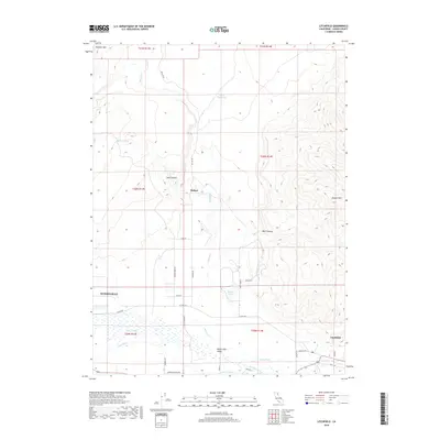
2018 Map of Litchfield
USGS Topo · Published 2018About this map
The Honey Lake Valley landscape in Lassen County is defined by its complex irrigation network and topographical extremes. The Susan River flows eastward across the southern portion of the sheet, feeding an intricate system of water management features including the Main Canal, Lower Canal, and Woodstock Canal. This infrastructure supports the agricultural activity around the settlement of Litchfield, where Johnson School Rd and Co Hwy A27 intersect. To the north, the terrain transitions sharply into the high ridges of Tunnison Mtn and Shaffer Mtn. Between these heights, smaller drainages like Petes Cr and Willow Cr wind toward the valley floor, while features like Adobe Reservoir and Wards Lake indicate seasonal or managed water storage in this arid environment. The small settlement of Belfast sits at the base of Sand Canyon, marking a historic node along Belfast Rd.
Find a feature on this map
39 named features on this map. Tap any name to fly to it.
Don’t see what you’re looking for? This feature index may not catch every label — zoom into the map to look around manually.
Map Details
Editions of this 2018 Litchfield Map
This is the sole edition of this map. No revisions or reprints were ever made.
Other maps of this area

1886 · Honey Lake
USGS Topo · 1:250,000

1891 · Honey Lake
USGS Topo · 1:250,000

1893 · Honey Lake
USGS Topo · 1:250,000

1954 · Susanville
USGS Topo · 1:62,500

1954 · Litchfield
USGS Topo · 1:62,500

1954 · Karlo
USGS Topo · 1:62,500

1954 · Fredonyer Peak
USGS Topo · 1:62,500

1955 · Westwood
USGS Topo · 1:250,000

1958 · Westwood
USGS Topo · 1:250,000

1959 · Westwood
USGS Topo · 1:250,000