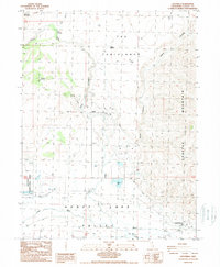
1988 Map of Litchfield
USGS Topo · Published 1989About this map
Honey Lake Valley anchors this late-1980s landscape, where the Susan River and Dill Slough define the hydrologic character of the basin floor. The settlement at Litchfield serves as the primary hub, situated near the western edge of Shaffer Mountain. To the west, the expansive grounds of the California Correctional Center represent a significant land-use shift in the high desert, complete with its own dedicated infrastructure such as Sewage Disposal Ponds.
Find a feature on this map
27 named features on this map. Tap any name to fly to it.
Don’t see what you’re looking for? This feature index may not catch every label — zoom into the map to look around manually.
Map Details
Editions of this 1988 Litchfield Map
This is the sole edition of this map. No revisions or reprints were ever made.
Other maps of this area

1886 · Honey Lake
USGS Topo · 1:250,000

1891 · Honey Lake
USGS Topo · 1:250,000

1893 · Honey Lake
USGS Topo · 1:250,000

1954 · Susanville
USGS Topo · 1:62,500

1954 · Litchfield
USGS Topo · 1:62,500

1954 · Karlo
USGS Topo · 1:62,500

1954 · Fredonyer Peak
USGS Topo · 1:62,500

1955 · Westwood
USGS Topo · 1:250,000

1958 · Westwood
USGS Topo · 1:250,000

1959 · Westwood
USGS Topo · 1:250,000