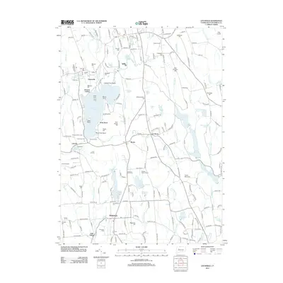
2012 Map of Litchfield
USGS Topo · Published 2012About this map
Bantam Lake dominates the central landscape of this Connecticut survey, surrounded by a dense network of recreational sites and historic settlements. The shoreline is punctuated by Dempsey Landing, Point Folly, and several youth camps including Camp Columbia and the Naugatuck YMCA Camp. This concentration of summer camps and the Morris Town Beach reflect the area's long-established role as a seasonal retreat. Further south, the rural character of Bethlehem and Morris is preserved through features like the Bethlehem Fairgrounds and several protected spaces such as the Bronson E Rockwell Reservation. Local infrastructure is represented by the Whelan Farms Airport and the expansive Wigwam Reservoir to the east. Genealogists will find numerous burial sites across the landscape, including Old Bethlehem Cem and the Lakeside Cem, marking the long-term residency of families in this corner of Litchfield County.
Find a feature on this map
215 named features on this map. Tap any name to fly to it.
Don’t see what you’re looking for? This feature index may not catch every label — zoom into the map to look around manually.
Map Details
Editions of this 2012 Litchfield Map
This is the sole edition of this map. No revisions or reprints were ever made.
Other maps of this area

1892 · Winsted
USGS Topo · 1:62,500

1892 · Cornwall
USGS Topo · 1:62,500

1892 · New Milford
USGS Topo · 1:62,500

1893 · Waterbury
USGS Topo · 1:62,500

1893 · New Milford
USGS Topo · 1:62,500

1893 · Cornwall
USGS Topo · 1:62,500

1903 · Cornwall
USGS Topo · 1:62,500

1904 · New Milford
USGS Topo · 1:62,500

1904 · Waterbury
USGS Topo · 1:62,500

1904 · Litchfield
USGS Topo · 1:125,000