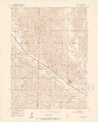
1951 Map of Litchfield
USGS Topo · Published 1953About this map
Mud Creek and the Chicago Burlington and Quincy railroad dominate this mid-century portrait of Central Nebraska. The village of Litchfield serves as the local hub, established where the rail line follows the natural valley of the creek. Rural life in the early 1950s is meticulously documented through a network of country schoolhouses, including Muddy Mills Sch, Round Grove Sch, and Shetler Sch, which anchored the surrounding farming townships of Algernon, Harrison, and Elk Creek. Along the northern boundary with Custer County, the landscape is defined by the drainages of Clear Creek and Stoddard Creek. This survey, produced as part of the Missouri River Basin development program, provides a clear view of the agricultural landscape before the widespread consolidation of rural districts, preserving the locations of sites like Gavin Siding and Gray Cem.
Find a feature on this map
23 named features on this map. Tap any name to fly to it.
Don’t see what you’re looking for? This feature index may not catch every label — zoom into the map to look around manually.
Map Details
Editions of this 1951 Litchfield Map
2 editions found
Other maps of this area

1951 · Arcadia SE
USGS Topo · 1:24,000

1951 · Litchfield SW
USGS Topo · 1:24,000

1951 · Litchfield NE
USGS Topo · 1:24,000

1951 · Hazard
USGS Topo · 1:24,000

1951 · Mason City
USGS Topo · 1:24,000

1951 · Ansley SE
USGS Topo · 1:24,000

1951 · Mason City SE
USGS Topo · 1:24,000

1951 · Arcadia SW
USGS Topo · 1:24,000

1951 · Litchfield
USGS Topo · 1:24,000

1955 · Broken Bow
USGS Topo · 1:250,000