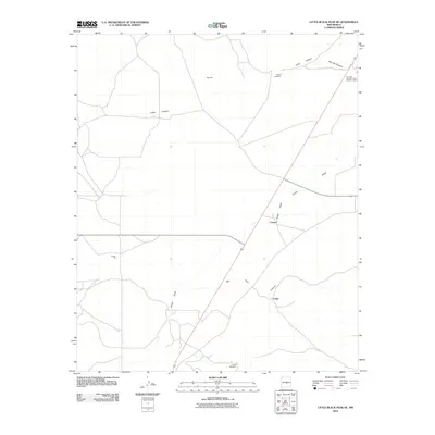
2010 Map of Little Black Peak NE
USGS Topo · Published 2010About this map
Iron Jack Number 1 and Number 2 Mine stands in the northeastern corner of this Lincoln County landscape, marking the industrial activity that has historically defined this high-desert region. The settlement of Cooper serves as a central point in an area characterized by dramatic drainage systems, including the long sweep of Largo Canyon and the Ancho Valley. The distribution of water resources is critical here, evidenced by isolated structures like Spade Windmill and Lizzard Windmill.
Find a feature on this map
12 named features on this map. Tap any name to fly to it.
Don’t see what you’re looking for? This feature index may not catch every label — zoom into the map to look around manually.
Map Details
Editions of this 2010 Little Black Peak NE Map
This is the sole edition of this map. No revisions or reprints were ever made.
Other maps of this area

1950 · Little Black Peak
USGS Topo · 1:62,500

1954 · Fort Sumner
USGS Topo · 1:250,000

1955 · Roswell
USGS Topo · 1:250,000

1958 · Fort Sumner
USGS Topo · 1:250,000

1958 · Roswell
USGS Topo · 1:250,000

1962 · Roswell
USGS Topo · 1:250,000

1973 · Ancho
USGS Topo · 1:24,000
1973 · White Oaks North
USGS Topo · 1:24,000

1980 · Corona
USGS Topo · 1:100,000
1981 · Polecat Draw
USGS Topo · 1:24,000