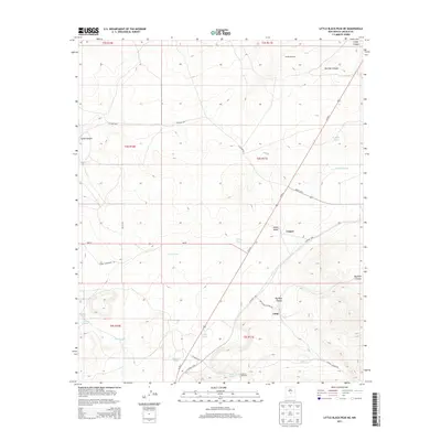
2013 Map of Little Black Peak NE
USGS Topo · Published 2013About this map
Ancho Valley provides the backdrop for this high-desert landscape in Lincoln County, where water management is the primary visible imprint on the land. The settlement of Cooper sits at the intersection of Ancho Hwy and Us-54 N, serving as a central point in an area dominated by numerous livestock tanks and windmills. These features, including Killgore Tank, Storey Tank, and Cooper Tank, reveal the extensive ranching infrastructure necessary to sustain operations in the arid New Mexico climate.
Find a feature on this map
33 named features on this map. Tap any name to fly to it.
Don’t see what you’re looking for? This feature index may not catch every label — zoom into the map to look around manually.
Map Details
Editions of this 2013 Little Black Peak NE Map
This is the sole edition of this map. No revisions or reprints were ever made.
Other maps of this area

1950 · Little Black Peak
USGS Topo · 1:62,500

1954 · Fort Sumner
USGS Topo · 1:250,000

1955 · Roswell
USGS Topo · 1:250,000

1958 · Fort Sumner
USGS Topo · 1:250,000

1958 · Roswell
USGS Topo · 1:250,000

1962 · Roswell
USGS Topo · 1:250,000

1973 · Ancho
USGS Topo · 1:24,000
1973 · White Oaks North
USGS Topo · 1:24,000

1980 · Corona
USGS Topo · 1:100,000
1981 · Polecat Draw
USGS Topo · 1:24,000