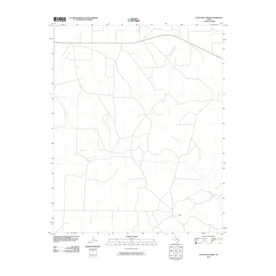
2010 Map of Little Blue Creek
USGS Topo · Published 2010About this map
Sneed Ranch sits within this Texas Panhandle landscape, where the drainage systems of the Canadian River basin define the local topography. The area is marked by a complex network of seasonal watercourses, including the convergence of Big Blue Creek and Little Blue Creek. The presence of Texas Beef Rd and Sneed Ranch reflects the enduring cattle and ranching economy that has shaped Moore County for generations. Further north and east, the terrain is cut by Ludlow Creek and Hay Creek, showing the typical sparse infrastructure of the High Plains where section lines and rural routes like Rd 32 provide the primary means of navigation across the open range.
Find a feature on this map
7 named features on this map. Tap any name to fly to it.
Don’t see what you’re looking for? This feature index may not catch every label — zoom into the map to look around manually.
Map Details
Editions of this 2010 Little Blue Creek Map
This is the sole edition of this map. No revisions or reprints were ever made.
Other maps of this area

1936 · Fourways
USGS Topo · 1:62,500

1939 · Sanford
USGS Topo · 1:62,500

1953 · Evans Canyon
USGS Topo · 1:24,000

1953 · Masterson
USGS Topo · 1:24,000

1953 · Spencer Draw
USGS Topo · 1:24,000

1954 · Amarillo
USGS Topo · 1:250,000

1958 · Amarillo
USGS Topo · 1:250,000

1965 · Dumas South
USGS Topo · 1:24,000
1965 · Dumas North
USGS Topo · 1:24,000
1972 · Little Blue Creek
USGS Topo · 1:24,000