1978 Map of Little Chicago
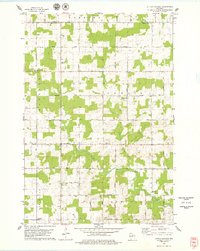
USGS Topo · Published 1979This historical map portrays the area of Little Chicago in 1978, primarily covering Marathon County as well as portions of Lincoln County. Featuring a scale of 1:24000, this map provides a highly detailed snapshot of the terrain, roads, buildings, counties, and historical landmarks in the Little Chicago region at the time. Published in 1979, it is one of 2 known editions of this map due to revisions or reprints.
Find a feature on this map
34 named features on this map. Tap any name to fly to it.
Don’t see what you’re looking for? This feature index may not catch every label — zoom into the map to look around manually.
Map Details
Editions of this 1978 Little Chicago Map
2 editions found
Historical Maps of Berlin Through Time
30 maps found

1902 Marathon
Marathon County, WI

1951 Doering
Marathon County, WI

1953 Marathon
Marathon County, WI

1963 Marathon
Marathon County, WI

1963 Wausau East
Marathon County, WI

1963 Wausau West
Marathon County, WI

1969 Rosholt NW
Marathon County, WI

1970 Big Eau Pleine Reservoir
Marathon County, WI

1970 Dancy
Marathon County, WI

1970 Dewey Marsh
Marathon County, WI

1970 Honey Island
Marathon County, WI

1973 Hogarty
Marathon County, WI

1973 Kalinke
Marathon County, WI

1978 Hamburg
Marathon County, WI

1978 Little Chicago
Marathon County, WI

1980 Corinth
Marathon County, WI

1981 Halder
Marathon County, WI

1981 Little Rose
Marathon County, WI

1981 Marathon
Marathon County, WI

1981 Marathon SW
Marathon County, WI

1981 Milan
Marathon County, WI

1982 Bevent
Marathon County, WI

1982 Brokaw
Marathon County, WI

1982 Mission Lake
Marathon County, WI

1982 Nutterville
Marathon County, WI

1982 Peplin
Marathon County, WI

1982 Ringle
Marathon County, WI

1982 Wien
Marathon County, WI

1993 Wausau East
Marathon County, WI

1993 Wausau West
Marathon County, WI