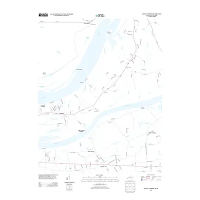
2013 Map of Little Cypress
USGS Topo · Published 2013About this map
The confluence of the Ohio River and the Tennessee River creates a water-bound landscape of sloughs, bars, and landings north of Calvert City. Small communities like Possum Trot and Little Cypress are connected by a network of local roads such as Old US 60 Rd and Sand Hill Rd. The map documents a high density of local cemeteries, including Robertson Cem, Bellamy Cem, and Leeper Cem, providing valuable points of reference for genealogists tracing family histories in Marshall County. Near the shoreline, Crowell Landing and Upper Hodge Landing indicate the region's historic reliance on river access. Further inland, Kincaid Mounds stands as a notable archaeological landmark amidst the bottomlands of Beaverdam Slough and Goodlow Slough, highlighting a deep history of habitation along these major waterways.
Find a feature on this map
133 named features on this map. Tap any name to fly to it.
Don’t see what you’re looking for? This feature index may not catch every label — zoom into the map to look around manually.
Map Details
Editions of this 2013 Little Cypress Map
This is the sole edition of this map. No revisions or reprints were ever made.
Other maps of this area

1926 · Paducah
USGS Topo · 1:62,500

1929 · Smithland
USGS Topo · 1:62,500

1929 · Paducah
USGS Topo · 1:62,500

1936 · Paducah
USGS Topo · 1:24,000

1936 · Elva
USGS Topo · 1:24,000

1936 · Smithland
USGS Topo · 1:48,000

1936 · Symsonia
USGS Topo · 1:24,000

1936 · Benton
USGS Topo · 1:48,000
1936 · Calvert City
USGS Topo · 1:24,000

1936 · Little Cypress
USGS Topo · 1:24,000