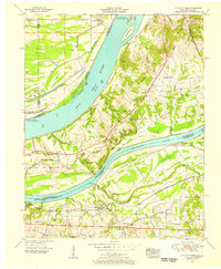
1954 Map of Little Cypress
USGS Topo · Published 1956About this map
The confluence of the Ohio River and Tennessee River dominates this mid-century survey, revealing a landscape defined by expansive bottomlands and essential transit corridors. Cultural landmarks like Kincaid Mounds sit in the floodplain of Black Bottom, providing evidence of ancient habitation long before the arrival of the Illinois Central railroad. The map documents a network of rural communities such as New Liberty, Ledbetter, and the curiously named Possum Trot, each connected by winding roads and proximity to the riverbanks.
Find a feature on this map
45 named features on this map. Tap any name to fly to it.
Don’t see what you’re looking for? This feature index may not catch every label — zoom into the map to look around manually.
Map Details
Editions of this 1954 Little Cypress Map
This is the sole edition of this map. No revisions or reprints were ever made.
Other maps of this area

1926 · Paducah
USGS Topo · 1:62,500

1929 · Smithland
USGS Topo · 1:62,500

1929 · Paducah
USGS Topo · 1:62,500

1936 · Paducah
USGS Topo · 1:24,000

1936 · Elva
USGS Topo · 1:24,000

1936 · Smithland
USGS Topo · 1:48,000

1936 · Symsonia
USGS Topo · 1:24,000

1936 · Benton
USGS Topo · 1:48,000
1936 · Calvert City
USGS Topo · 1:24,000

1936 · Little Cypress
USGS Topo · 1:24,000