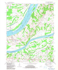
1982 Map of Little Cypress
USGS Topo · Published 1983About this map
The confluence of the Ohio River and the Tennessee River dominates this 1982 survey, capturing the industrial and agricultural landscape of western Kentucky. The map highlights the strategic river-and-rail infrastructure of the era, where the Illinois Central Gulf Railroad crosses the landscape near Little Cypress and Possum Trot. On the Illinois side, the Kincaid Mounds stand as a significant archaeological landmark in the Black Bottom region, contrasting with the active river commerce evidenced by Crowell Landing and Upper Hodge Landing. Social centers of the late 20th century are well-documented, from the Cedar Crest Nursing Home to local congregations at Vaughn Chapel and Siloam Ch. The terrain transitions from the broad alluvial plains of Towhead Island to the higher ground of the Divide, where numerous family and community burial grounds like Sand Hill Cem and Oak Grove Cem provide valuable data for genealogical research.
Find a feature on this map
59 named features on this map. Tap any name to fly to it.
Don’t see what you’re looking for? This feature index may not catch every label — zoom into the map to look around manually.
Map Details
Editions of this 1982 Little Cypress Map
This is the sole edition of this map. No revisions or reprints were ever made.
Other maps of this area

1926 · Paducah
USGS Topo · 1:62,500

1929 · Smithland
USGS Topo · 1:62,500

1929 · Paducah
USGS Topo · 1:62,500

1936 · Paducah
USGS Topo · 1:24,000

1936 · Elva
USGS Topo · 1:24,000

1936 · Smithland
USGS Topo · 1:48,000

1936 · Symsonia
USGS Topo · 1:24,000

1936 · Benton
USGS Topo · 1:48,000
1936 · Calvert City
USGS Topo · 1:24,000

1936 · Little Cypress
USGS Topo · 1:24,000