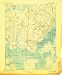
1893 Map of Little Egg Harbor
USGS Topo · Published 1907About this map
Tuckerton serves as a coastal hub on this late nineteenth-century survey, situated where the maritime landscape of Little Egg Harbor meets the inland pine forests. The industrial and transit patterns of the era are clearly visible via the Tuckerton Railroad, which links settlements like Manahawken, Cedar Run, and Staffordville along the shore. Inland, the importance of water power and timber is evidenced by Stafford Forge and numerous named branches such as Tub Mill Branch and Beaver Branch.
Find a feature on this map
98 named features on this map. Tap any name to fly to it.
Don’t see what you’re looking for? This feature index may not catch every label — zoom into the map to look around manually.
Map Details
Editions of this 1893 Little Egg Harbor Map
4 editions found

Other maps of this area

1884 · Whitings
USGS Topo · 1:62,500

1887 · Atlantic City
USGS Topo · 1:62,500

1888 · Pemberton
USGS Topo · 1:62,500

1888 · Barnegat
USGS Topo · 1:62,500

1888 · Little Egg Harbor
USGS Topo · 1:62,500

1888 · Long Beach
USGS Topo · 1:62,500

1888 · Whitings
USGS Topo · 1:62,500

1890 · Great Egg Harbor
USGS Topo · 1:62,500

1890 · Mullica
USGS Topo · 1:62,500

1893 · Great Egg Harbor
USGS Topo · 1:62,500
Featured Places
- Galloway Township, NJ
- Stafford Township, NJ
- Barnegat Township, NJ
- Little Egg Harbor Township, NJ
- Tuckerton, NJ