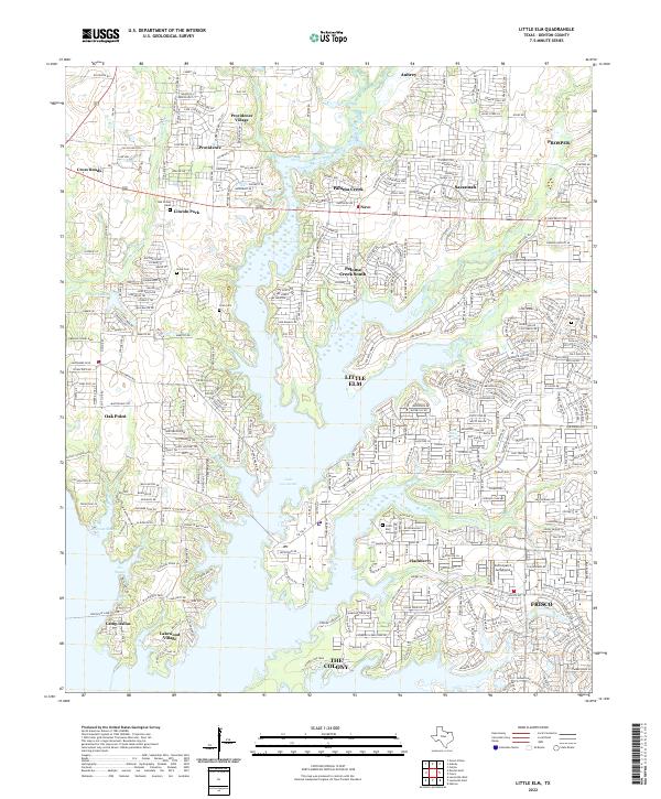
2022 Map of Little Elm
USGS Topo · Published 2022About this map
Lake Lewisville dominates the central landscape of this North Texas survey, its intricate shoreline creating numerous inlets and peninsulas that define the local geography. The map reveals the extensive residential growth surrounding the water, particularly in the city of Little Elm and the master-planned communities of Paloma Creek and Savannah to the north. Unlike earlier eras of agrarian spacing, the dense network of roads like Fishtrap Rd and Cape Cod Blvd reflects a rapidly modernizing suburban corridor between the expanding hubs of Frisco and Prosper.
Find a feature on this map
232 named features on this map. Tap any name to fly to it.
Don’t see what you’re looking for? This feature index may not catch every label — zoom into the map to look around manually.
Map Details
Editions of this 2022 Little Elm Map
This is the sole edition of this map. No revisions or reprints were ever made.
Other maps of this area

1925 · Mc Kinney 3-c
USGS Topo · 1:48,000

1929 · Frisco
USGS Topo · 1:62,500

1954 · Sherman
USGS Topo · 1:250,000

1958 · Sherman
USGS Topo · 1:250,000

1960 · Frisco
USGS Topo · 1:24,000

1960 · Green Valley
USGS Topo · 1:24,000

1960 · Celina
USGS Topo · 1:24,000

1960 · Aubrey
USGS Topo · 1:24,000
1960 · Lewisville East
USGS Topo · 1:24,000
1960 · Hebron
USGS Topo · 1:24,000