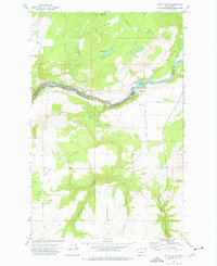
1973 Map of Little Falls
USGS Topo · Published 1977About this map
The Spokane River carves a deep path through this 1970s landscape, demarcating the border between Stevens and Lincoln counties. The central focus is the Little Falls settlement and hydroelectric site, where Plant I and a nearby substation mark the industrial utility of the river's descent. To the west, the river expands into Lake Roosevelt, part of the Coulee Dam National Recreation Area, where the spillway elevation is recorded at 1289 feet.
Find a feature on this map
35 named features on this map. Tap any name to fly to it.
Don’t see what you’re looking for? This feature index may not catch every label — zoom into the map to look around manually.
Map Details
Editions of this 1973 Little Falls Map
This is the sole edition of this map. No revisions or reprints were ever made.
Other maps of this area

1944 · Wellpinit
USGS Topo · 1:62,500

1945 · Reardan
USGS Topo · 1:62,500

1948 · Turtle Lake
USGS Topo · 1:62,500

1950 · Turtle Lake
USGS Topo · 1:62,500

1953 · Reardan
USGS Topo · 1:62,500

1953 · Wellpinit
USGS Topo · 1:62,500

1953 · Ritzville
USGS Topo · 1:250,000

1955 · Spokane
USGS Topo · 1:250,000

1958 · Spokane
USGS Topo · 1:250,000

1959 · Ritzville
USGS Topo · 1:250,000