1950 Map of Little Falls
USGS Topo · Published 1950About this map
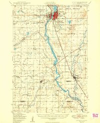
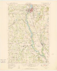
The Mississippi River serves as the central artery for this 1948 field-checked landscape, flowing through the heart of Little Falls past Shays Island and Blanchard Dam. This era shows a region defined by its rural townships and established parish life, anchored by numerous country schools and religious landmarks like St Mary Church and the St Stanislaus Kostka Cemetery. The industrial and transport patterns of the mid-century are evident in the crossing routes of the Northern Pacific and the Minneapolis St Paul and Sault Ste Marie railroads, which connected smaller settlements like Bowlus and Royalton to the larger river economy. Local governance is represented by several rural hubs including the Pike Creek Town Hall and Swan River Town Hall, while the inclusion of the Little Falls Airport signals the modernizing infrastructure of the post-war period.
Find a feature on this map
90 named features on this map. Tap any name to fly to it.
Don’t see what you’re looking for? This feature index may not catch every label — zoom into the map to look around manually.
Map Details
Editions of this 1950 Little Falls Map
2 editions found