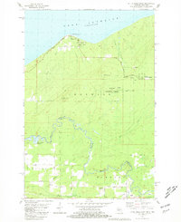
1980 Map of Little Girls Point
USGS Topo · Published 1981About this map
The rocky northern coastline of the Upper Peninsula meets the cold waters of Lake Superior in this study of the borderlands between Michigan and Wisconsin. The namesake Little Girls Point serves as a prominent landmark on the shore, featuring a historic Indian Burial Grounds and a Picnic Area within the Little Girls Point County Park. Inland, the landscape is defined by the winding course of the Montreal River, which acts as the state boundary, and the dense timberlands of the Ottawa National Forest. Significant changes in elevation are noted at Point Mountain and near the Saxon Falls Flowage, where the river's descent is utilized for water management. The map details a network of rural roads and gravel pits, reflecting the area's geological and industrial character in the late twentieth century.
Find a feature on this map
1 named feature on this map. Tap any name to fly to it.
Don’t see what you’re looking for? This feature index may not catch every label — zoom into the map to look around manually.
Map Details
Editions of this 1980 Little Girls Point Map
This is the sole edition of this map. No revisions or reprints were ever made.
Other maps of this area

1940 · Upson
USGS Topo · 1:48,000

1943 · Little Girls Point
USGS Topo · 1:24,000

1943 · Upson
USGS Topo · 1:48,000

1943 · Ironwood
USGS Topo · 1:48,000

1943 · Little Girl Point
USGS Topo · 1:48,000

1953 · Ashland
USGS Topo · 1:250,000

1955 · Ironwood
USGS Topo · 1:24,000

1955 · Ironwood
USGS Topo · 1:62,500
1956 · Saxon
USGS Topo · 1:24,000

1956 · North Ironwood
USGS Topo · 1:62,500