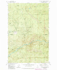
1981 Map of Little Goat Mountains
USGS Topo · Published 1984About this map
St Joe National Forest and the North Fork Clearwater River dominate this 1980s landscape at the boundary of Shoshone and Clearwater counties. The area is characterized by heavy timber and significant elevation changes, ranging from the depths of the Dworshak Reservoir in the southwest to the heights of the Little Goat Mountains in the northeast. Isolated structures like the Blue Heaven Cabin and a Lookout Tower on Smith Ridge point to the region's history of forest management and remote habitation.
Find a feature on this map
39 named features on this map. Tap any name to fly to it.
Don’t see what you’re looking for? This feature index may not catch every label — zoom into the map to look around manually.
Map Details
Editions of this 1981 Little Goat Mountains Map
3 editions found
Other maps of this area

1914 · Avery
USGS Topo · 1:125,000

1917 · Avery
USGS Topo · 1:125,000

1923 · Washington Creek
USGS Topo · 1:125,000

1936 · Boehls Butte
USGS Topo · 1:48,000

1943 · Boehls Butte
USGS Topo · 1:62,500

1956 · Wallace
USGS Topo · 1:250,000

1956 · Hamilton
USGS Topo · 1:250,000

1959 · Hamilton
USGS Topo · 1:250,000

1960 · Wallace
USGS Topo · 1:250,000

1960 · Hamilton
USGS Topo · 1:250,000