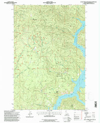
1994 Map of Little Green Mountain
USGS Topo · Published 1997About this map
Little Green Mountain and Jericho Mtn dominate this 1990s terrain, where the rugged drainages of the Clearwater National Forest meet the waters of the Dworshak Reservoir. The landscape is defined by its industrial history and conservation boundaries, featuring the Jericho Mine in the northwest and the administrative lines of the St Joe NF and Sjnf. Numerous watercourses, including Meadow Creek, Swamp Creek, and Bear Creek, carve through the elevations toward the reservoir's edge, which is dotted with designated Campsites. This survey captures the region after the mid-century creation of the reservoir, illustrating how the rising water transformed the local topography into a series of points and inlets like Bartlett Point. The map also documents the Clearwater Special Parallel, a key surveying marker through this timbered backcountry.
Find a feature on this map
25 named features on this map. Tap any name to fly to it.
Don’t see what you’re looking for? This feature index may not catch every label — zoom into the map to look around manually.
Map Details
Editions of this 1994 Little Green Mountain Map
This is the sole edition of this map. No revisions or reprints were ever made.
Other maps of this area

1923 · Washington Creek
USGS Topo · 1:125,000

1936 · Boehls Butte
USGS Topo · 1:48,000

1938 · Headquarters
USGS Topo · 1:48,000

1943 · Boehls Butte
USGS Topo · 1:62,500

1944 · Headquarters
USGS Topo · 1:62,500

1955 · Pullman
USGS Topo · 1:250,000

1956 · Hamilton
USGS Topo · 1:250,000

1958 · Pullman
USGS Topo · 1:250,000

1959 · Hamilton
USGS Topo · 1:250,000

1960 · Hamilton
USGS Topo · 1:250,000