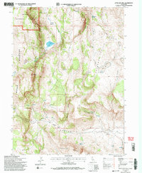
1993 Map of Little Hat Mtn.
USGS Topo · Published 1996About this map
The Warner Mountains dominate this high-desert landscape in the northeastern corner of California, where the Modoc National Forest meets the arid topography of the Coppersmith Hills. This 1993 revision documents a region defined by its water sources and ranching history, centered around Little Hat Mtn. Life here revolves around the seasonal availability of water, marked by sites like Newland Reservoir, Newland Springs, and Wire Lake.
Find a feature on this map
35 named features on this map. Tap any name to fly to it.
Don’t see what you’re looking for? This feature index may not catch every label — zoom into the map to look around manually.
Map Details
Editions of this 1993 Little Hat Mtn. Map
2 editions found
Other maps of this area

1886 · Alturas
USGS Topo · 1:250,000

1886 · Honey Lake
USGS Topo · 1:250,000

1886 · Granite Range
USGS Topo · 1:250,000

1889 · Long Valley
USGS Topo · 1:250,000

1891 · Honey Lake
USGS Topo · 1:250,000

1892 · Alturas
USGS Topo · 1:250,000

1893 · Honey Lake
USGS Topo · 1:250,000

1894 · Granite Range
USGS Topo · 1:250,000

1954 · Observation Peak
USGS Topo · 1:62,500

1954 · Vya
USGS Topo · 1:250,000