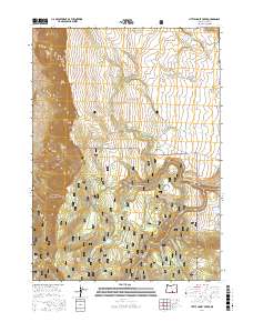
2017 Map of Little Honey Creek
USGS Topo · Published 2017About this map
Abert Rim dominates the western edge of this Lake County landscape, where the high desert meets the wooded reaches of the Fremont National Forest. This 2017 survey captures a remote interior of Oregon characterized by a network of seasonal water sources and specialized trails. The presence of the Southern Oregon Intertie Trail and the Warner Snowmobile Trail indicates a terrain managed for long-distance recreation and winter access through the high timber. Significant water management and natural hydrology are evident in the naming of the Fitzgerald Reservoir and numerous isolated points like Vee Springs and O'Hallihan Spring. The map also details distinctive local landmarks such as Washing Machine Flat and the ecological transition at White Pine Marsh, providing a precise record of the eastern Oregon backcountry.
Find a feature on this map
39 named features on this map. Tap any name to fly to it.
Don’t see what you’re looking for? This feature index may not catch every label — zoom into the map to look around manually.
Map Details
Editions of this 2017 Little Honey Creek Map
This is the sole edition of this map. No revisions or reprints were ever made.
Other maps of this area

1955 · Klamath Falls
USGS Topo · 1:250,000

1958 · Klamath Falls
USGS Topo · 1:250,000

1964 · Crooked Creek Valley
USGS Topo · 1:24,000

1964 · Valley Falls
USGS Topo · 1:24,000

1966 · Coglan Buttes SE
USGS Topo · 1:24,000

1968 · Crook Peak
USGS Topo · 1:24,000
1968 · Drake Peak NE
USGS Topo · 1:24,000

1968 · Lake Abert South
USGS Topo · 1:24,000
1968 · Little Honey Creek
USGS Topo · 1:24,000
1968 · Cooper Draw
USGS Topo · 1:24,000